The Fort Worth Press - NASA launches satellite for landmark study of Earth's water

USD -
AED 3.67301
AFN 69.000039
ALL 89.100812
AMD 387.749422
ANG 1.804889
AOA 928.499145
ARS 962.883803
AUD 1.467136
AWG 1.8
AZN 1.67429
BAM 1.753412
BBD 2.022028
BDT 119.677429
BGN 1.76065
BHD 0.376899
BIF 2894
BMD 1
BND 1.293151
BOB 6.920294
BRL 5.426596
BSD 1.001511
BTN 83.756981
BWP 13.175564
BYN 3.277435
BYR 19600
BZD 2.018612
CAD 1.35575
CDF 2870.999576
CHF 0.847602
CLF 0.033735
CLP 930.86013
CNY 7.067969
CNH 7.07117
COP 4164.6
CRC 518.757564
CUC 1
CUP 26.5
CVE 99.25031
CZK 22.484598
DJF 177.720197
DKK 6.682601
DOP 60.19579
DZD 132.248004
EGP 48.529451
ERN 15
ETB 117.498985
EUR 0.89585
FJD 2.199303
FKP 0.761559
GBP 0.75274
GEL 2.729842
GGP 0.761559
GHS 15.701827
GIP 0.761559
GMD 68.504511
GNF 8652.502481
GTQ 7.741513
GYD 209.457218
HKD 7.79305
HNL 24.949766
HRK 6.799011
HTG 131.977784
HUF 353.169873
IDR 15184.65
ILS 3.774495
IMP 0.761559
INR 83.7267
IQD 1310
IRR 42092.486976
ISK 136.429747
JEP 0.761559
JMD 157.339131
JOD 0.708703
JPY 142.599594
KES 129.000218
KGS 84.27499
KHR 4070.000132
KMF 441.350266
KPW 899.999433
KRW 1328.670133
KWD 0.30492
KYD 0.834476
KZT 479.593026
LAK 22085.000164
LBP 89268.117889
LKR 304.846178
LRD 194.250419
LSL 17.500056
LTL 2.95274
LVL 0.60489
LYD 4.744976
MAD 9.695037
MDL 17.473892
MGA 4554.99989
MKD 55.240768
MMK 3247.960992
MNT 3397.999955
MOP 8.038636
MRU 39.715027
MUR 45.870459
MVR 15.360052
MWK 1736.000073
MXN 19.314966
MYR 4.210269
MZN 63.849901
NAD 17.500827
NGN 1617.903458
NIO 36.76964
NOK 10.59437
NPR 134.027245
NZD 1.603065
OMR 0.384971
PAB 1.001511
PEN 3.744997
PGK 3.9142
PHP 55.580499
PKR 278.100947
PLN 3.829151
PYG 7817.718069
QAR 3.64025
RON 4.456099
RSD 104.878972
RUB 92.168294
RWF 1342
SAR 3.752542
SBD 8.306937
SCR 13.508937
SDG 601.497109
SEK 10.162603
SGD 1.2923
SHP 0.761559
SLE 22.847303
SLL 20969.494858
SOS 570.999951
SRD 29.853055
STD 20697.981008
SVC 8.762579
SYP 2512.529936
SZL 17.500677
THB 33.137982
TJS 10.644256
TMT 3.5
TND 3.024015
TOP 2.349801
TRY 34.078401
TTD 6.806508
TWD 31.930198
TZS 2724.43986
UAH 41.500415
UGX 3718.795247
UYU 41.141269
UZS 12734.999337
VEF 3622552.534434
VES 36.733195
VND 24580
VUV 118.722009
WST 2.797463
XAF 588.099177
XAG 0.032482
XAU 0.000387
XCD 2.70255
XDR 0.742235
XOF 587.503383
XPF 107.282634
YER 250.324992
ZAR 17.60865
ZMK 9001.202706
ZMW 26.062595
ZWL 321.999592
  • RBGPF

    3.5000

    60.5

    +5.79%

  • RYCEF

    0.4000

    6.95

    +5.76%

  • SCS

    -0.8000

    13.31

    -6.01%

  • CMSC

    0.0650

    25.12

    +0.26%

  • NGG

    -1.2200

    68.83

    -1.77%

  • BP

    0.3300

    32.76

    +1.01%

  • BTI

    -0.3100

    37.57

    -0.83%

  • GSK

    -0.8100

    41.62

    -1.95%

  • RELX

    0.7600

    48.13

    +1.58%

  • RIO

    2.2700

    65.18

    +3.48%

  • VOD

    -0.1700

    10.06

    -1.69%

  • BCC

    7.6300

    144.69

    +5.27%

  • BCE

    -0.4200

    35.19

    -1.19%

  • CMSD

    0.0300

    25.01

    +0.12%

  • JRI

    -0.0400

    13.4

    -0.3%

  • AZN

    0.3200

    78.9

    +0.41%

NASA launches satellite for landmark study of Earth's water
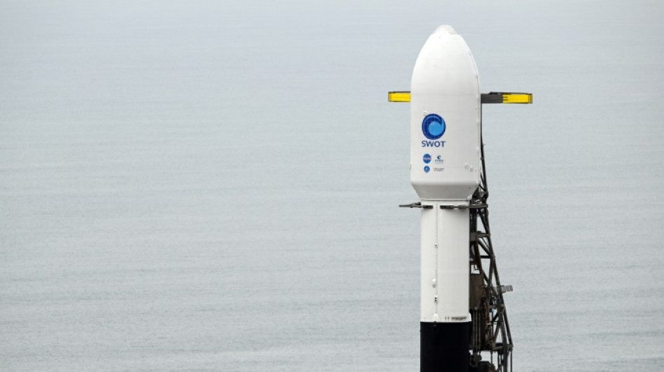
NASA launches satellite for landmark study of Earth's water / Photo: © AFP

NASA launches satellite for landmark study of Earth's water

A satellite lifted off Friday from California on a mission to survey nearly all bodies of water on Earth, offering key insights on how they influence or are impacted by climate change.

Text size:

The Surface Water and Ocean Topography (SWOT) satellite, a billion-dollar project jointly developed by NASA and France's space agency CNES, took off at 1146 GMT atop a SpaceX rocket from the Vandenberg Space Force Base.

According to a statement from NASA, it will start collecting scientific data in about six months after undergoing checks and calibrations.

"SWOT will bring us a revolutionary advance in our understanding of how water moves around our planet," said Karen St. Germain, NASA's Earth Science Division director, ahead of the launch.

"We will be able to see detail in eddies and currents and circulation in the oceans that we have never been able to see before."

She said this would help predict floods in areas with too much water, and manage water in regions prone to drought.

Selma Cherchali, of the French space agency CNES, told a press conference on Tuesday that the satellite represents a "revolution in hydrology. We are aiming to provide fine-scale observations ten times better than the current technology."

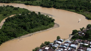
From a height of 890 kilometers (550 miles), SWOT will have the clearest view yet of the world's oceans, allowing it to track the rise in sea levels, as well as rivers and lakes.

Researchers will be able to get data on millions of lakes, rather than the few thousands currently visible from space.

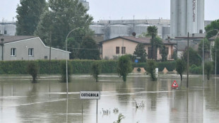
"We know with climate change that Earth's water cycle is accelerating. What this means is that some locations have too much water, others don't have enough," said Benjamin Hamlington, a NASA research scientist.

"We're seeing more extreme droughts, more extreme floods, precipitation patterns are changing, becoming more volatile. So it's really important that we try to understand exactly what is happening."

The mission is meant to last for three and a half years, but could be extended until five years, or even more, said SWOT's project head at CNES, Thierry Lafon.

The US and French space agencies have worked together in the field for more than 30 years. A previous satellite developed by the partners, TOPEX/Poseidon, improved understanding of ocean circulation and its effect on global climate.

L.Rodriguez--TFWP